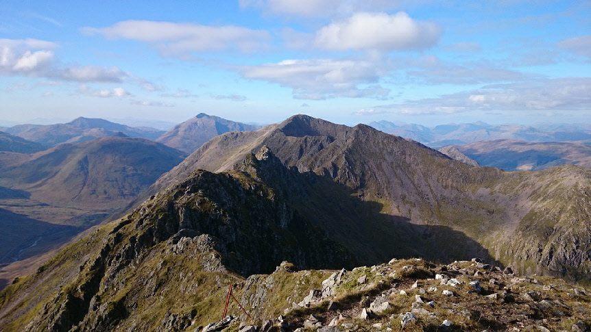
The Aonach Eagach ridge, looking west towards Sgorr nam Fiannaidh.
Sgorr nam Fiannaidh
Meaning - Peak of the Fingalians
Summit Location - NN14049, 58302
Height - 967m
Munro Number - 188
Meall Dearg
Meaning - Red Hill
Summit Location - NN16136, 58373
Height - 953m
Munro Number - 212
Distance - 8.4km
Total Ascent - 1108m
Estimated Time - 2 hrs up to Meall Dearg / 3 hrs across to Sgorr nam Fiannaidh /
2 hrs down
Difficulty - 5/5
OS Explorer Map - 384
Climbed - 2014
Weather - Warm, sunny spells, increasing medium-level cloud.
Meall Dearg and Sgorr nam Fiannaidh are two Munros on the north side of Glen Coe.
They can be climbed separately though the purist would want to combine the two peaks,
which means taking on the Aonach Eagach ridge, a name which strikes fear into many.
The Munro bagger is unlikely to find a bigger challenge in mainland Britain. If you
do this route and enjoy it, you should probably head for Skye.
One shouldn't plan a traverse of the Aonach Eagach unprepared. To some extent, some
of the hype and fear is perhaps unjustified, but it's not a route you should tackle
blindly. The scrambling grade II ridge is sheer, fairly long, the options for escape
are limited and on occasion people do fall off and are seriously injured (or worse).
Ascent is normally from Allt-na-Ruigh. There's a steep climb on a good path up the
southeast ridge of Am Bodach. From there there's a short, steep down-climb (I've
seen parties rope up for this bit), followed by a relatively easy ridge which takes
you to the first Munro, Meall Dearg. From there the real fun starts, the Aonach Eagach
ridge proper. A path descends to the ridge, then you climb a chimney before tackling
a series of pinnacles. The pinnacles are separated by very narrow parts of the ridge
(think a 30cm wide rock with a 300m+ sheer drop either side). I'm a reasonably confident
scrambler but at least one of these pinnacles gave me pause for thought, the exposure
is great and the moves do require a little thinking through.
Once you've reached Stob Coire Lèith, a Munro top at the end of the Aonach Eagach,
the hard part is over. A broader ridge climbs to Sgorr nam Fiannaidh, the second
and final Munro of the day. The difficulty is over after this but a word of caution;
the descent from here is straightforward but there are no shortcuts. Don't be tempted
by the Clachaig Gully - this may seem to offer a short route to the pub but is slippery,
steep and badly eroded. There've been numerous fatalities descending this route.
Don't survive the traverse of the Aonach Eagach to die in descent - the recommended
route descends to the north west to a bealach between Cnap Glas and Sgorr na Ciche
(Pap of Glencoe) then continues down to the road beside a burn. It may take 30 minutes
longer but you'll likely live to enjoy your pint in the Clachaig Inn.
The average Munroist will probably want to leave this route for a dry, calm day.
It's also an epic winter route but the short days and tougher weather make that a
more difficult proposition altogether. I climbed this at the end of a long sunny
autumn week, which allowed plenty of opportunity for some practice scrambles elsewhere
in Glen Coe to get the legs and arms warmed up!
Route
1 - Start from the small car park by the A82 at Allt-na-Ruigh. An obvious path climbs
up rocky terrain to the top of Am Bodach. There’s some very easy scrambling moves
to get you in the mood for what’s ahead.
2 - From the summit of Am Bodach there’s a steep down-climb to get you to the first
part of the ridge. Many would argue this is one of the hardest bits of this route
so take care! If you don’t like what you see head back - at least you’ll have ticked
off Am Bodach. The route first descends to the right on a series of exposed ledges
and then veers left across the rock face. Thousands of crampon scratches mark the
way, if you don’t see any you’re probably going the wrong way - or climbing in winter!
Down-climb, eventually moving right on to a broad(ish) ridge where there’s some old
fence posts.
3 - There’s a decent path on this next bit of ridge, you’ll see more fence posts
as you progress easily to the road summit of Meall Dearg to tick off Munro number
one. The next bit of the route is quite complicated, if these instructions are tricky
to follow the safest thing to do is to stay on the crest of the ridge.
4 - The Aonach Eagach proper begins with an easier descent on a good path, though
the ridge is much narrower here. You reach the first pinnacle and then there’s a
steeper down-climb, followed by an ascent up a chimney. The rock is near vertical
here but there are plenty of hand/foot holds.
5 - The path continues on the ridge that seems to get narrower and narrower. A first
set of small pinnacles can be climbed directly, with a tricky descent from the last,
or avoided on the left. A descent then takes you to the narrowest part of the ridge
- a couple of rocks seemingly balanced atop a very airy gap! The rocks are solid
though and this very narrow bit is very short.
6 - A steep down-climb comes next, before a series of three larger pinnacles. It’s
not possible to go around these - they must be climbed directly. The exposure is
significant here and it’s probably the trickiest part of the route. Take great care.
The last and largest pinnacle can be ascended slightly from the right hand side which
is a little easier. Follow the crampon marks! Descent from this last pinnacle requires
a bit of thought.
7 - After the descent from the last pinnacle you’ll leave the Aonach Eagach ridge
on some steep, slabby rock, which brings you to the Munro top of Stob Coire Lèith
without any undue difficulties. This marks the end of the scrambling.
8 - A good path on a much wider ridge leads you to the summit of Sgorr nam Fiannaidh,
the second and final Munro. It’s a pretty steep slog so hopefully you’ve some energy
left in the tank.
9 - There’s a couple of options for descent from Sgorr nam Fiannaidh. 1) return by
route of ascent or 2) for the less extreme and arguable more sane a descent to the
north west towards the Pap of Glencoe. Don’t be tempted to descend via the Clachaig
Gully, it might look like a quick route to the pub but the rock is steep and extremely
slippery. What begins as a good path soon disappears - this route has claimed many
lives through the years - don’t risk it.
10 - The easiest descent is to head west, then north west to head over Cnap Glas
to the col immediately south of the Pap of Glencoe. There’s a path but it seems to
come and go. From the col, descend westwards via the burn. Lower down you’ll pick
up a track that leads to the Glencoe village road.
11 - Once you reach the road you can turn left for the Youth Hostel (1.5km) the Clachaig
pub (3km) and the start point of this walk (9km). If you want to hitch a lift back
to your car it may be quicker to turn right and walk to Glencoe village (1.5km) which
is on the main A82 road.