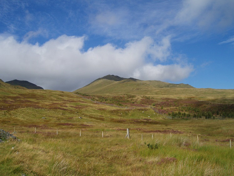
Beinn Ghlas from the visitor centre car park.
Ben Lawers
Meaning - Mountain of the Hoof/Claw or Loud Mountain
Summit Location - NN63552, 41424
Height - 1214m
Munro Number - 10
An Stuc
Meaning - Rocky Cone
Summit Location - NN63878, 43094
Height - 1118m
Munro Number - 34
Meall Garbh
Meaning - Rough Hill
Summit Location - NN64439, 43753
Height - 1118m
Munro Number - 35
Beinn Ghlas
Meaning - Grey/Green Mountain
Summit Location - NN62534, 40456
Height - 1103m
Munro Number - 47
Meall Greigh
Meaning - Hill of the Cattle Herd
Summit Location - NN67401, 43796
Height - 1001m
Munro Number - 136
Distance - 21.3km
Total Ascent - 1524m
Time - 2hrs to Beinn Ghlas / 0.75hrs to Ben Lawers / 1hr to An Stuc / 0.5hrs to Meall
Garbh / 1.25hrs to Meall Greigh / 3hrs return to visitor centre. Total 8.5hrs.
Difficulty - 4/5
OS Explorer Map - OL48
Climbed - 2007
Weather - Day one: sunny intervals with cloud around the height of the peaks. Windy.
Day two: Overcast at first with peaks in the cloud. Clouds lifting and breaking later
with the sun coming out.
The Ben Lawers range has seven Munros. Four of these are over 1100m which make them
among the highest peaks in Scotland. You’d need to be very athletic to tackle all
seven in one outing, so most split them into two, tackling the five on this page
in one trip and saving Meall Corranaich and Meall a’ Choire Leith, which lie to the
west, for another day.
The route described here to tackle the eastern five Munros is still a long day by
Scottish standards, and the shortest route back, described here, traverses the rough
and pathless slopes of Beinn Ghlas. There’s also some scrambling involved when descending
An Stuc. All this makes for one of the tougher outings described on this website,
but you’re never far from an escape route if the weather turns or someone gets tired.
Escape would probably be to the southeast, where you should be able to pick up a
track leading down to the A827. Pick you descent route carefully though, An Stuc
in particular has a craggy eastern side.
I took two days to ascend these five peaks. In a slight variation to the route described
below I headed up in the afternoon of day one, following the route described to climb
Beinn Ghlas and Ben Lawers. I then camped high on Bealach Dubh, just to the south
of An Stuc. Day two saw me continue on the route over the remaining peaks. It was
on the return route where I deviated from what is described below; instead of continuing
down to the track I descended in a more westerly direction to Lochan nan Cat, then
climbed the headwall above the lochan (to retrieve my tent at Bealach Dubh). I then
returned to the visitor centre by the route of ascent (though skipping the climb
back up Beinn Ghlas by using the avoiding path to the north. Some extra effort but
well worth it for a stunning (if windy) wild camp.
Route
1 - Start at the car park near the Ben Lawers National Nature Reserve visitor centre.
Follow the path up through the conservation area. Shortly after you exit this area
the path forks. Take the right option onto Beinn Ghlas’ south ridge. The path climbs
steeply to the summit of Beinn Ghlas, marked by a cairn.
2 - Continue to follow the well worn path in a northeasterly direction, descending
to a bealach just under 1km away. The path then begins to climb the 200m or so to
the summit of Ben Lawers, marked with a trig point.
3 - Ignore the path leading down to the east, instead follow the other path to the
north. This drops along a broad ridge then rises a little to cross Creag an Fhithich.
The path then drops steeply to a bealach, before a thigh-burning climb to the summit
of An Stuc, which is marked by a cairn.
4 - The descent of An Stuc can be a little tricky, where the elevation drops over
100m in less than 100m horizontal distance. This means a steep downward scramble.
There are a number of possible lines, try to follow the crampon scratches for the
most commonly travelled (and therefore most straightforward) route. Take care, the
exposure isn’t great nor the scrambling particularly difficult but the rock is loose
and eroded. There’s no easy way to avoid this section, except perhaps for a time
consuming detour down An Stuc’s northwest ridge followed by a turn to the right to
contour around the corrie in Fin Glen followed by a reascent of Meall Garbh.
5 - Once you’ve made it down the scrambly bit the crux of the route is behind you.
You’ll pick up the path again to climb in a northeasterly direction to the summit
of Meall Garbh, again marked by a cairn. Take the obligatory summit photographs and
then continue along the path which descends first in a northerly direction, before
turning to the east. The path follows the remains of an old fence down to a wide
bealach, around 1.5km from Meall Garbh.
6 - The footpath is a little less easy to make out as you cross the boggy bealach
but continue in an easterly direction, following the old fence as it begins to climb
Meall Greigh. Near the top of the climb the line of the old fence turns left, whereas
you should carry straight on up the broad ridge, passing a number of subsidiary tops
until you reach the summit, marked by a huge cairn.
7 - The initial descent is straight down the southern slopes of Meall Greigh to some
old shielings and a dam at NN66192, 42726. From here you can follow the track in
a southeastern direction as it contours the hill. You’ll ford some small burns and
pass more old shielings. After about 4km you’ll reach a point where the track starts
to weave its way downhill and a small footpath leads off to the right toward a burn
and another dam (NN64482, 39689).
8 - At this point you can continue down on the track which eventually descends to
meet the A827 or you can take the small footpath to cross the burn above the dam,
continuing across pathless, open ground to return to the visitor centre, as described
in step nine below). The latter would save an additional 5km of walking along the
road to return to the visitor centre but it’s not a route I’d recommend in really
poor weather, or if it’s quite late in the day, given the largely featureless terrain.
9 - If there’s plenty of time before sunset and you’ve opted for the shortest route,
cross the Allt an Tuim Bhric burn above the dam and contour around the southern slopes
of Beinn Ghlas for about 2km. Once you’re back at the south ridge and close to the
conservation area passed through on ascent, you can descend to the visitor centre
which lies about another 1km away.