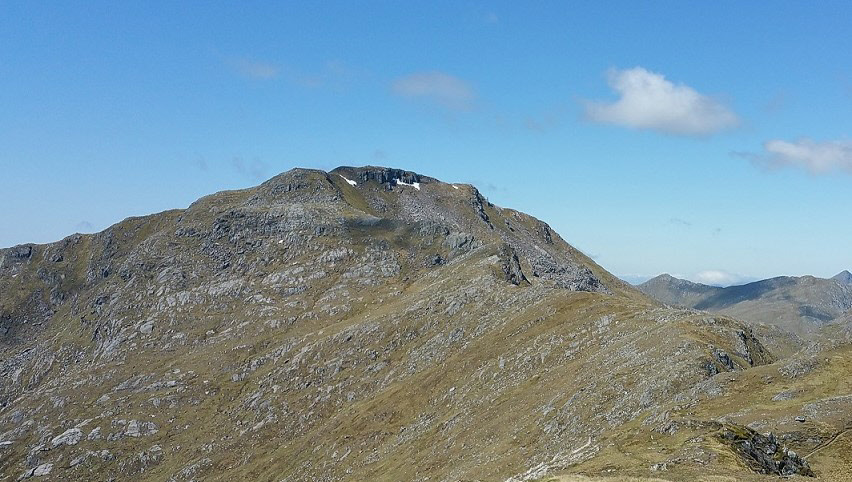
The summit from Sgurr Coire nan Eiricheallach.
Meaning - Peak of the Shellfish
Summit Location - NG98401, 06538
Height - 1027m
Munro Number - 104
Distance - 10.7km
Total Ascent - 983m
Estimated Time - 4hrs00
Difficulty - 2/5
OS Explorer Map - 414
Climbed - 2016
Weather - Warm, sunny, a little high-level cloud.
It'd been a fine week in Scotland, I'd had some great walks and the weather was fantastic
too. Rain was on the way, but there was just time to squeeze in one last walk.
Save Sgurr a' Mhaoraich for a clear day, the views from the top are fantastic. This
part of Scotland is really packed with mountains and on a decent day you'll see probably
around a sixth of all the Munros from the peak.
Unlike some of the more remote hills in nearby Knoydart and Glen Affric, this peak
is a mere half-day walk. That is if you have a car. You can follow the bumpy and
twisty "road" to Kinloch Hourn and park at the base. This road is not for the faint-hearted
though, it's almost 25km to the main road at the A87 an it took me nearly an hour.
You get the idea.
This route is a slightly longer variation, taking in the nearby peak of Sgurr Coire
nan Eiricheallach and ascending the ridge that links it with Sgurr a' Mhaoraich.
There's very little reascent required and it spices up what is relatively straightforward
peak. The ridge is fairly broad and although the final climb to the summit is pretty
steep any craggy bits are easily avoided.
Route
1 - There are a number of verges to park a car, about 25km along the Kinloch Hourn
road, not long after you cross the bridge over Loch Quoich. You’ll see a small cairn
by the road and a number of muddy paths leading up the grassy slopes. This is your
way.
2 - The muddy paths soon join to one fairly decent path which winds its way up the
ridge. As the gradient eases the path crosses to the right hand side of the ridge
(marked Bac nan Canaicheam on the map). You’ll reach a false summit, and then the
path approaches Sgurr Coire nan Eiricheallach from the south.
3 - Descend westwards to follow the ridge. The going is easy enough. You’ll cross
over a stone wall a couple of times. The ridge climbs and falls, but never by very
much. The final climb up to the Munro peak is steeper, but it’s a path all the way
rather than a scramble.
4 - The top is soon reached - enjoy the view! On a clear day you'll see the Knoydart
peaks to the south west, Glen Shiel and the Saddle to the north west, Glen Affric
to the north east and perhaps even Ben Nevis to the south east.
5 - You could return by route of ascent, or via the south ridge of Sgurr a’ Mhaoraich.
To do the latter, first retrace your steps for about 50m. Then descend directly south,
to the west of the crags. You may pick out a path at times but it seems to come and
go.
6 - Follow the ridge in a southerly direction. Some bits are a little steep but it’s
all a walk rather than a scramble. Take care to continue south, don’t descend towards
the east as you may find yourself on much steeper terrain. Don’t be tempted to try
to find a shortcut to the road. The ground in the corrie is probably very wet anyway!
7 - You’ll probably have lost the path by this point, but as long as you keep heading
south until the ridge eases near the road you’ll be fine. A short walk east along
the road will return you to your car.